Petersville Recreational Mining Area Alaska
Here are some tips and info:
General Information
Access: Access is via Petersville Road.
See the article Gold and Platinum Placer Deposits in Denali State Park Open for Recreational Miners.
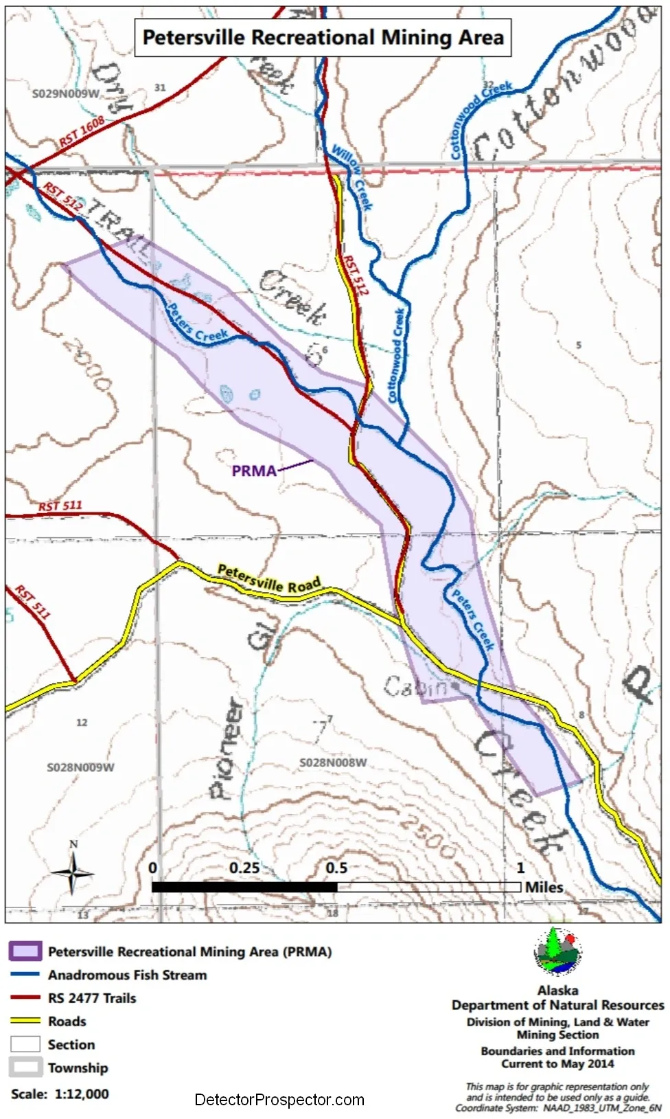
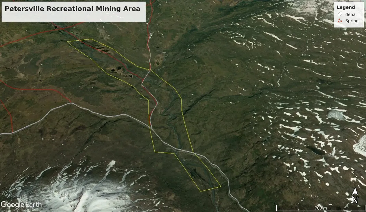
Above is a map of the Petersville Recreational Mining Area. Click here for a Google Earth KML file of the Petersville Recreational Mining Area. Source: Alaska DNR. Shown in the above image are the limits of the recreational mining area in yellow, roads in gray, RS2477 historic trails in red. Adjacent mining claims and leases, if any, not shown. However, almost all ground outside the Rec mining area is probably claimed.
An excellent video, with drone footage, of the Petersville Road, and Petersville Recreational Mining Area. FREE mining in Alaska - Petersville gold prospecting area(Youtube link). Schwendi Nov 15, 2022 PETERSVILLE Check out our latest Alaska Gold Adventure:
![]() • NEW Alaska Gold Adventure - exploring...
On our Alaska trip 2022, we made a short side trip to the beautiful
Petersville area. There is a recreational mining area, where everybody
can go gold prospecting. It's really worth the trip, we enjoyed our time
there. Search google for: Petersville recreational mining area
Auf unserer Alaska 2022 Reise machten wir auch einen kurzen
Abstecher in die schöne Petersville Gegend. Es hat dort einen freien
Goldwaschbereich, wo jeder goldwaschen darf. Die Anreise lohnt sich, wir
haben unsere Zeit dort genossen Suche auf google nach: Petersville
recreational mining area.
• NEW Alaska Gold Adventure - exploring...
On our Alaska trip 2022, we made a short side trip to the beautiful
Petersville area. There is a recreational mining area, where everybody
can go gold prospecting. It's really worth the trip, we enjoyed our time
there. Search google for: Petersville recreational mining area
Auf unserer Alaska 2022 Reise machten wir auch einen kurzen
Abstecher in die schöne Petersville Gegend. Es hat dort einen freien
Goldwaschbereich, wo jeder goldwaschen darf. Die Anreise lohnt sich, wir
haben unsere Zeit dort genossen Suche auf google nach: Petersville
recreational mining area.
Interested in buying a lease or mining claim in the Petersville area (or anywhere else)? Read Fact Sheet: Investigating Claims Before You Buy first, from the Alaska DNR. Also of related interest to both prospective buyers as well as claim/mine owners and lessees is this informative report from the Nevada Bureau of Mines titled "Gold from Water (and Other Scams)"(Free download link).
Alaska Resource Data File for Peters Creek
If you are looking for the "town of Stevensville Alaska" in the Yentna Mining District as seen on TV, I regret to inform you that it is fictitious. It is set in the abandoned camp of Petersville.
Parking, Camping, and Mining: The State right-of-way/easement extends for 50 feet on either side of the centerline of the Petersville Road, and there are numerous pullouts. Camping and parking, as well as mining, are free of charge. Before you cross the bridge at Peters Creek at Mile 32 you will enter the Petersville Recreational Mining Area, an area set aside by the State of Alaska for the citizens to pan and mine for gold. If you don't know how, it's easy to learn and fun to do. This is also another outstanding area to camp. There are about 2 miles of Peters Creek contained within the rec mining area, as well as part of Cottonwood Creek and other side streams.
You can pan, or use a pick and shovel, sluice, Rocker box, Highbanker, metal detector, dowsing rods, or suction dredge, with some considerations. No suction dredging is allowed in Peters Creek after 15 July, and you need a permit, see link below. Dredging and highbanking in old mining cuts, pits and other areas adjacent and away from the salmon-bearing stream may be permissible.
There is a date range for the allowance of these activities by the Alaska Department of Fish and Game and the allowance varies depending on the water source. Peters Creek is considered anadromous throughout the entirety of the PRMA [Petersville Recreational Mining Area](effective 2015) because Chinook spawning has been documented within the waterbody throughout the PRMA. Small-scale suction dredging activities are only authorized between May 15th and July 15th along Peters Creek to protect fish habitat. These activities are not authorized on Peters Creek from July 15th – October 31st.
Cottonwood Creek and its tributaries are also considered anadromous, although they contain no documented spawning areas in the outlying system. Small-scale suction dredging activities are authorized between May 1st and October 31st on Cottonwood Creek and its tributaries. There is a small segment of an unnamed resident fish stream located within the PRMA, south of Cottonwood Creek. The unnamed resident fish stream is open to recreational mining year-round.
Gold mining is not just a part of Alaska's past, but it is still an important activity in many areas of the state today. You might like to try your hand at finding some of the precious metal. Recreational gold panning and prospecting are permitted, with some restrictions, on most public lands in Alaska. On private lands or mining claims, the owner's permission is needed to mine even if you are just gold panning. Alaska Native villages and corporation lands are private. (SoA: Recreational Gold Mining in Alaska). See Time Saving Tips for Prospective Gold Seekers from the Alaska DNR.
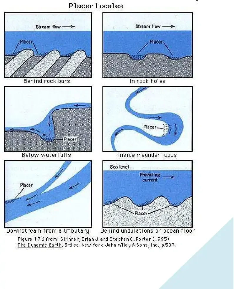
The best places to look for placer gold deposits are where the water is slack, such as the inside bend of the stream. Bedrock outcrops and areas around and under boulders are other prime targets. Also look for areas where previous miners have stacked rocks. Gold is usually found in the greatest concentrations on bedrock, and can work its way 6' deep or more in cracks in the bedrock. A prybar is handy for mining these areas, and a turkey baster will help to clean those cracks. Consider that fine material such as sand or clay usually contains only fine gold, whereas coarse (pebbly) material contains coarse and fine gold. An exception is clay filled cracks in bedrock.
Topographic Maps: U.S.G.S. Talkeetna C-2 is the main map, those adjoining it will provide excellent coverage
Weather: The weather is subject to change rapidly due to our closeness to Denali. You could wake up to a clear, cloudless day, and temperatures could soar into the 80's, or the wind could shift, and the temperature can drop 30 degrees in a few minutes, followed by a cold, windy rain. If you expect to be more than a couple of hours away from your vehicle or camp, you would be well advised to take along a day pack with a light rain jacket or poncho, among other items.
Licenses and Permits- Check with various State and Federal agencies for information relating to fishing, hunting, and land use requirements, and have them up-to-date and on you, because even in the wilderness there are officials. I don't want you to get in trouble while on your golden safari.
Peters Creek becomes an anadromous stream south of the confluence with Cottonwood Creek. Limited suction dredging activities may be allowable if using a suction dredge with a nozzle intake of 6” in diameter or less and engine with 18 hp or less may be conditionally allowed. Permits are required from the Alaska Department of Fish and Game and the Department of Environmental Conservation prior to beginning any suction dredging activities with a hose or motor of any size.
ADF&G authorizations for small-scale suction dredging activities are issued based on the location within the recreational area as specified in the ADF&G General Permit. Small-scale suction dredging activities are only authorized between May 15th and July 15th in Peters Creek. Small-scale suction dredging activities are authorized between May 1st and October 31st in Cottonwood Creek. Recreational mining activities are allowed year-round in the unnamed resident fish stream segment south of Cottonwood Creek.
Methods of placer mining that require the use of hydraulic equipment (i.e. the use of pumped or flowing water to remove overburden or move gravels) and dredges greater than 6” in diameter are not allowed within the PRMA. The use of heavy operating equipment is not allowed.
The local channel for CB radios is channel 19. Most cell phones work, but are better at the higher elevations. FRS/GMRS hand held 'walkie-talkies' are a good option to keep in touch with your group, but have a limited range. Use of GMRS frequencies require an FCC license.
It's always a good idea to file a trip plan and leave it with someone.
Youtube video of the Petersville Rec Mining Area: https://www.youtube.com/watch?v=97kZPPoH7lw&ab_channel=DiscoverwithSchwendi
Contents
General Information
Images and Maps of the Petersville Recreational Mining Area
Fact sheet
Alaska Statutes
ARDF Link
License
Images and Maps of the Petersville State Recreational Mining Area
Petersville Recreational Mining Area Alaska
Information and Factsheets

More Information
When you visit, please remember to be a good neighbor. Fill in any holes you dig, respect the mining claims and property adjacent to the area, but most of all have a great experience. Wherever you may be, please respect the environment. Don't litter. Pick up any litter you do find and pack it out. Don't take anything out you didn't bring in, except for minerals and memories. And don't leave anything behind.
There are very few places that are accessible wilderness. Even fewer where you can spend time and find some color, or a fish. For information on the history and geology of the area see the main page, and visit the links on these pages.
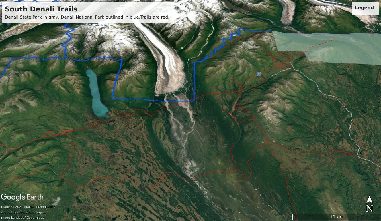
Some information about panning in nearby Denali State Park: Recreational gold panning is allowed in Denali State Park only if the following conditions are met: no motorized equipment is used; only a gold pan or a shovel, or both, may be used; and no chemicals are used. Recreational gold panning in Denali State Park may be conducted on an anadromous fish stream only between May 16 and July 14 annually. For the purpose of recreational gold panning, a person may not extract or disturb natural materials above the ordinary high water line or where live vegetative matter exists in Denali State Park
This information is shared with the acknowledgement that the reader is responsible for his or her acts.
Dutch Creek: stream, heads W of Dutch Hills, flows SW 10 mi. to Granite Creek, 37 mi. NW of Talkeetna, Alaska Ra.; 62°32’10” N, 150°10’10” W; (map 81).
Prospectors’ name reported in 1906 by R. W. Porter, USGS.
Dutch Hills: ridge, elev. 4,400 ft., extends NE 15 mi. from 1958 terminus of Kahiltna Glacier, 30 mi. NW of Talkeetna, Alaska Ra.; 62°35’30” N, 150°58’00” W; (map 81).
Prospectors’ name reported in 1911 by S.R. Capps (in Brooks, 1912, pl 9), USGS.
Gopher Gulch: ravine, in Dutch Hills, trends NE 0.5 mi. to Willow Creek, 29 mi. NW of Talkeetna, Alaska Ra.; 62°34’45” N, 150°50’45” W; (map 81)
Prospectors’ name reported in the 1930’s by USGS.
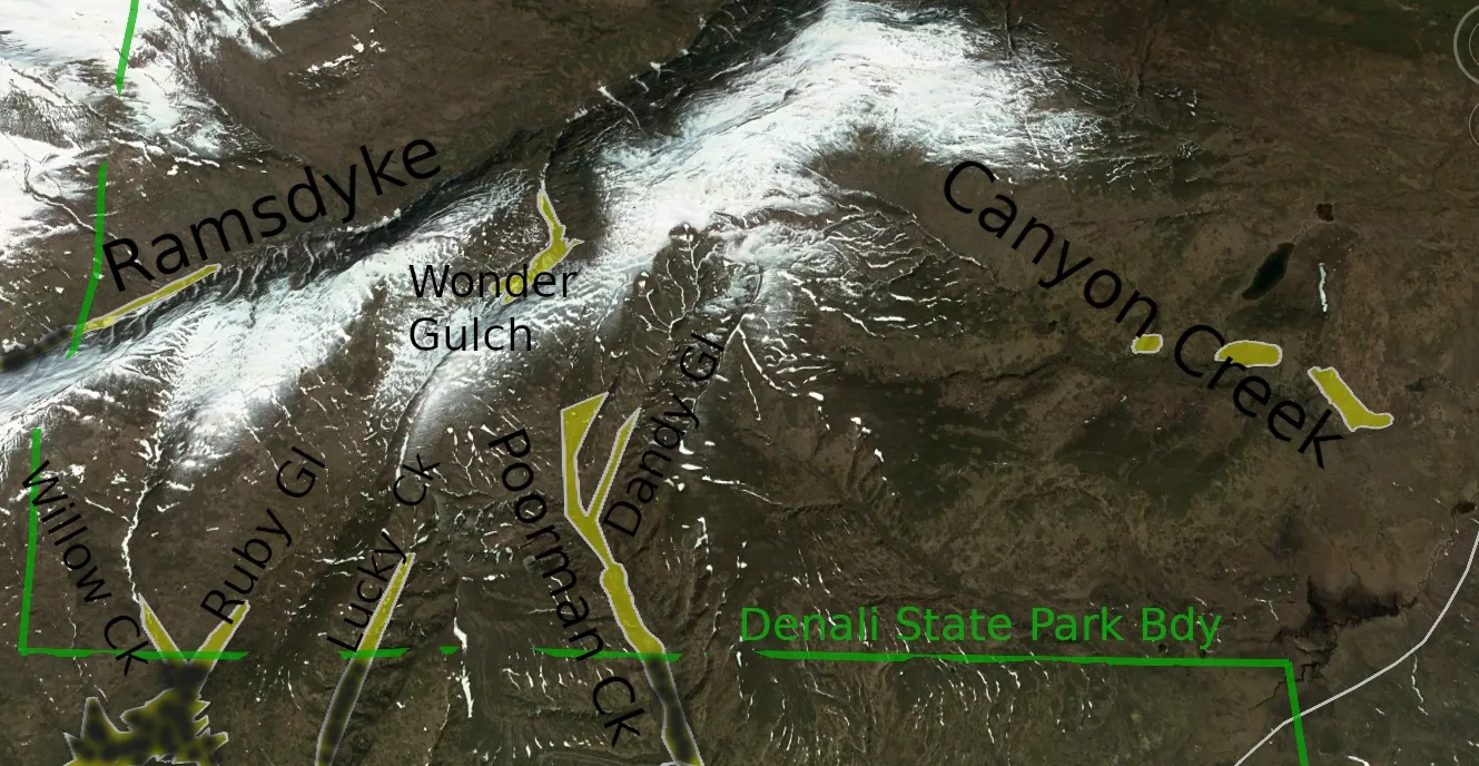
Ramsdyke Creek: heads in Dutch Hills, flows NE 5 mi. to Tokositna River.
Prospectors’ name reported in 1906 by R. W. Porter, USGS.
Tokositna River var. Tokichitna, Tokoshitna. Tanaina Indian name meaning “stream from treeless area”, reported to A. H. Brooks in 1902 by prospector George Aberhardt.
Peters Creek: stream, heads in Dutch Hills, flows S 45 mi. to Kahiltna River, 26 mi. SW of Talkeetna, Alaska Ra. ; 62" 10'40" N, 150"- 52'45" W; (map 81). Prospectors' name reported in 1906 by R. W. Porter, USGS.
Peters Hills: mountains, 3,800 ft., extend SW 18 mi. from Tokositna River, 24 mi. NW of Talkeetna, Alaska Ra.; 62"31'15" N, 150°48'30" W; (map 81). Local name reported in 1906 by R. W. Porter, USGS.
Petersville: locality, on Peters Creek, 24 mi. NW of Talkeetna, Alaska Ra.; 62”29'45" N, 150"- 46'00" W; (map 81). Mining camp reported in 1934 by USGS. The Petersville post office was located here from 1936 to 1939 (Ricks, 1965, p. 51).
Source: Dictionary of Alaska place names U.S.G.S. Professional Paper 567
By: Donald J. Orth
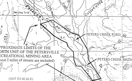
Fact Sheet Title: Petersville Recreation Mining Area Alaska DNR, Division of Mining, Land & Water April 2004 [Some edits have been made and are clearly indicated] [Map that was included in the Fact Sheet] A new state law designates two areas of public land near the Petersville Road (southwest of Denali State Park) for recreational mining and other general public recreation.
Senator Rick Halford proposed the new areas as part of a bill sponsored by Representatives Tim Kelly and Gene Therriault. The Legislature's action confirms an idea first proposed in 1993: to give Alaskans and visitors a place where they could find good "color" in their gold pans without worrying that they were jumping someone's mining claim. That's a problem in most gold-rich areas because of existing mining claims staked under state or federal law. To prevent this conflict, both units of the Petersville Recreational Mining Area are closed to the staking of new mining claims. The new area will give the public a chance to gain first-hand experience in recreational mining, help celebrate the Gold Rush Centennial, and maybe take home a few gold nuggets.
How do I get to the new Petersville Recreational Mining Area? Although part of the new area is still in the process of being acquired from the federal government, the north unit is already in state ownership and open to public use. [Note: The South Unit was never implemented] Access is via the Petersville Road. See the other side of this fact sheet for a map showing the general location of the Petersville Recreational Mining Area's north unit. The last few miles of the access route are rough, recommended only for four-wheel drive vehicles, vehicles with high clearance, four-wheelers, mountain bikes, and the like.
How will the Petersville Recreational Mining Area be developed? The new law requires the Department of Natural Resources (DNR) to prepare a plan for the management, use, and development of the area, including the mining methods that can be used while still protecting important habitat such as for salmon in Peters Creek. The Department of Fish and Game and the Department of Transportation will participate in the management plan, with full public input. In the meantime, the unit is already open to use.
What facilities are there now? There are no developed campsites, sanitation facilities, drinking-water supplies, or trash cans at present. Visitors should be prepared for self-sufficient, low-impact camping. Please don't leave any trash or litter, and be careful with campfires.
What kind of mining can I do? Recreational gold panning, mineral prospecting, or mining using light portable field equipment, such as pick and shovel, pan, earth auger, or a backpack power drill or auger are allowed without any permit. Also, you can obtain a permit from the DNR Office of Habitat Management & Permitting (OHMP) to use a small suction dredge.
How can I get a permit for suction dredging? Contact OHMP, at 550 W 7 Ave., Suite 1420, Anchorage, AK 99501; phone 907-269-8690 or fax 907-269-5673. Suction dredging in Peters Creek closes at midnight July 15 each year to protect salmon habitat. Link for small scale mining in the Petersville Recreational Mining Area (PDF).
Can I stake a mining claim in the Petersville Recreational Mining Area? No, new mining claims are not allowed.
Are there any mining claims already in the area? There are no mining claims within the Petersville Recreational Mining Area, but plenty of them outside the boundary. The Department of Natural Resources clearly marked the upstream and downstream ends of the north unit during the summer of 1997, and is looking for a way to show the side boundaries too. In the meantime, you can avoid any conflict by doing your prospecting and mining only on the Peters Creek valley floor, not up Cottonwood Creek or on the higher ground where there are likely to be mining claims. Any minerals within the boundaries of these claims are the property of the claim owner. Please respect the mining locators' rights under the laws of the State of Alaska.
Of course, you are free to walk across these mining claims or use them for camping, hunting, fishing, four-wheeling, and other recreation, but you can't mine on them without the claimant's permission.
What else can I do in the area? The Petersville Recreational Mining Area and surrounding public lands are highly popular for hunting, fishing, hiking, four-wheeling, snowmachining, cross-country skiing, and dog mushing. Where can I get detailed maps? You can purchase topographical maps that show more detail on the area. Ask for USGS Topographical map Talkeetna C2. If you like, you can research status plats showing the location of existing mining claims weekdays between the hours of 10:00 a.m. to 5:00 p.m. at the DNR Public Information Center (see below). [You can also get detailed free maps and data using the Alaska DNR "Alaska Mapper" site at https://mapper.dnr.alaska.gov/ ].
How can I get more information? Contact the Department of Natural Resources: Public Information Center 550 West 7 Ave., Suite 1260 Anchorage, AK 99503-5929 907-269-8400 Public Information Center 3700 Airport Way Fairbanks, AK 99709-4699 907-451-2705 Division of Mining, Land & Water 550 West 7 Avenue, Suite 1070 Anchorage, AK 99501-3579 907-269-8600
Petersville Recreational Mining Area Management Plan Public Notice
Petersville Recreational Mining Area Management Plan Public Notice and links to more information.
Related Alaska Statutes: Alaska Statutes. Title 41. Public Resources Chapter 23. Multiple Use Management of Public Resources Section 630. Petersville Recreational Mining Area. AS 41.23.630.
Petersville Recreational Mining Area.
(a) The purpose of this section is to establish the area described in (f) of this section as the Petersville Recreational Mining Area. The Petersville Recreational Mining Area is established to provide for a public recreational mining area to permit public recreational activities and to allow other multiple-use activities to continue as long as the activities do not detract from the primary purpose for the establishment of the Petersville Recreational Mining Area.
(b) The commissioner is responsible for the management of the surface and subsurface estate within the Petersville Recreational Mining Area necessary to carry out the purposes of this section. The commissioner shall adopt and may revise a management plan and shall adopt regulations for the management, use, and development of the Petersville Recreational Mining Area.
The management plan, including any revisions, and regulations adopted by the commissioner shall be developed in consultation with the commissioner of fish and game and the commissioner of transportation and public facilities. The management plan and regulations must address, but not be limited to,
(1) the methods of mining permitted within the Petersville Recreational Mining Area;
(2) the types of mining equipment that may be used within the Petersville Recreational Mining Area; (3) the protection of habitat within the Petersville Recreational Mining Area; and
(4) other restrictions consistent with the purposes stated in this section.
(c) Except as provided in this subsection, the Petersville Recreational Mining Area is open to recreational mining under this section. The commissioner of fish and game is responsible for the management of the fish and game resources and the public use of fish and wildlife resources within the Petersville Recreational Mining Area consistent with the purposes stated in this section. The commissioner of fish and game shall issue a general permit to the public authorizing recreational mining activities subject to seasonal restrictions on the mining activities within specified waterbody areas necessary to maintain fishery resources within the Petersville Recreational Mining Area.
(d) The Petersville Recreational Mining Area is closed to mineral entry under AS 38.05.185 - 38.05.275
(e) The commissioner shall permit the construction and realignment of the Petersville Road within the Petersville Recreational Mining Area as is determined necessary by the commissioner of transportation and public facilities.
(f) The vacant and unappropriated state-owned land and water and the state land and water acquired in the future that lie within the following described mining claims described in United States Mineral Survey No. 2384 are reserved from all uses incompatible with the purposes of this section and are assigned to the department for control and management as the Petersville Recreational Mining Area:
(1) Township 28 North, Range 8 West, Seward Meridian Sections 6 - 8: Daisy No. 2; Hidden Treasure No. 1; Hidden Treasure No. 2; Flora No. 1; Flora No. 2; Moose No. 1; Beaver No. 1; Alexander No. 1; Alexander No. 2; Lost Shovel No. 1; Lost Shovel No. 2; Peters Creek No. 8; Peters Creek No. 9; Peters Creek No. 10; Peters Creek No. 11; Sections 21 and 28: Alder No. 1; Alder No. 2; Cottonwood No. 3; Cottonwood No. 4; Seattle No. 1; Seattle No. 2; Contact No. 1; Contact Claim No. 2; Willow Claim; Korter Bench.
(2) Township 28 North, Range 9 West, Seward Meridian Section 1: Daisy No. 2; Hidden Treasure No. 1.
License
This work is licensed under a Creative Commons Attribution 4.0 International License.
Caution
Additional Information
Cautionary Legal Safe Harbor: While every effort is made to provide accurate, up-to-date information, data and maps, the GPS data, maps, and written documentation provided herein is for information, education, and illustrative mapping purposes only and no implied, expressed, or written certainty, warranty or guarantee as to the accuracy and/or legitimacy is made by Blue Ribbon Mine LLC or any other entities. The materials provided are subject to change, and it is not our responsibility to notify you of any changes. Blue Ribbon Mine LLC and any other entities are to be held completely harmless and at no fault for any and all liabilities and issues arising from its use or misuse, whether intended or not, by recreational or other users that knowingly or unknowingly use this GPS and other information at their own discretion and sole risk.
Think Before You Go.

View of the Petersville Recreational Mining Area and Peters Hills Alaska from The Blue Ribbon Mine
Discover the Best Mining Solutions with The Blue Ribbon Mine
A handy Drive Guide to the Petersville Road and some information about the Petersville State Recreational Mining Area.
If you're looking for adventures and hospitality, visit our neighbors Ken and Winona Lee at The Cache Creek Cabins.
December 6 is National Mining Day
The Historic Blue Ribbon Mine Potato Patch Alaska
Mile 1 Blue Ribbon Mine Road, Gopher Mountain, Dutch Hills, Yentna Mining District, Trapper Creek, Alaska, USA
Copyright © 1985-2025 Blue Ribbon Mine LLC. Gopher Mountain, Potato Patch, and The Historic Blue Ribbon Mine Alaska, SM. And Dennis R. Garrett.
This website is for education, amusement and informational purposes only, and does not constitute an offer to sell, a solicitation of an offer to buy, or a recommendation of any security or any other product or service by Blue Ribbon Mine, LLC. All brands, logos and other service marks are the property of their owner and does not constitute an endorsement.
This work is licensed under a Creative Commons Attribution 4.0 International License.
This site powered by OmniTech0 and Linux
